Pelverata Falls
Pelverata Falls
PUFF-O-METRE
OVERVIEW
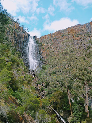
This incredible waterfall has the number 2 come up constantly when being talked about. Two ways to see it, two ways to access the main event, two rivers meeting at the top to form the main falls and even two waterfalls can be seen when the conditions are just right.....
Starting with the main way people like to visit these falls is the lower hiking track. Turning off Pelverata Road and onto Croswells Road, you will follow this to the end where you'll be greeted with a makeshift carpark and signage to indicate the start of the track. This is an easy going track that's predominantly uphill all the way to the falls lookout. During the wetter periods, you'll be faced with plenty of mud however this is worth it for the end result being a flowing waterfall. In the summer months, the mud is less of an issue however this means you'll see less flow, if any, of the waterfall at the lookout. If you hike this track during or just after a large downfall of rain, you may also get the pleasure of seeing a second smaller waterfall on the way to the main event.
Now there is also a less used track by hikers that allows you a view of these falls from above....
Turning off at Margate, follow Van Morey Road to the end. This is about 8km of sealed and gravel road until you come to a carpark on the right hand side. There are three more houses after this carpark however if you plan to hike this whole track then don't go any further.
If you have a 4WD that has clearance and a good set of tyres then you should be comfortable in travelling the next 6km to a parking location that's displayed in the photos below. This 6km has ruts and water crossings, depending on the time of the year, therefore only travel if you feel comfortable to do so. The base for most of the track is hard rock, even under the water, so the going isn't too bad. Please stop and check each water hole/crossing before entering.
At the 6km mark, its time to make a choice. You can either park up and hike the remainder of the track or continue on in your 4WD. It's a comfortable hike without any real difficulty since it's designed to allow 4WDs access. If you choose to drive this remainder section then it's a very good idea to either have a second vehicle with you or a functioning winch as there are a couple of sections that are deep muddy ruts. It's certainly achievable but if you're uncertain then it's a good idea to play it safe by hiking the last section.
Once you get to the end of the upper track, you are met with some incredible cliffs and two majestic rivers that meet just before going over the cliff face to make Pelverata Falls. There is plenty of space for a relaxed lunch location while you take in the water views from one side and the breathtakingly beautiful cliffs on the other side.
 |
| Lower Hiking Track |
 |
| Complete Upper Track |
 |
| 4WD Section Of Upper Track |
 |
| Hiking Section Of Upper Track |
 |
| Parking Location For Upper Track - 6.2KM |


Comments
Post a Comment